
Civil Surveying Road Curves: Horizontal Geometry, Parabolic Vertical Alignments & Casio-BASIC Programs
Standard Road Curve Formulas Summary
For a circular curve with Radius $R$ and Deflection Angle $\Delta$: Tangent Distance: $T = R \tan(\Delta/2)$ • Length of Curve: $L = (\pi R \Delta) / 180^\circ$ • Long Chord: $C = 2 R \sin(\Delta/2)$ • External Distance: $E = R(\sec(\Delta/2) - 1)$ • Middle Ordinate: $M = R(1 - \cos(\Delta/2))$. You can test all these formulas instantly in our LocalDoc Scientific Calculator.
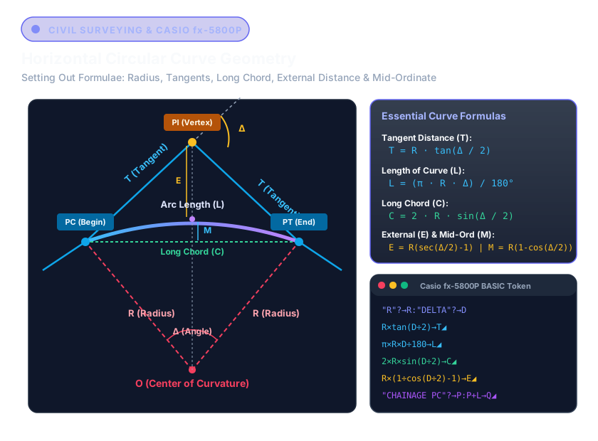
1. Anatomy of Horizontal Circular Curves in Highway Alignment
In transportation engineering, horizontal curves transition vehicles safely between two intersecting straight lines (tangents). The geometry is defined by the intersection angle $\Delta$ (measured at the Point of Intersection, PI) and the designated design radius $R$.
| Curve Parameter | Symbol | Formula | Worked Example ($R=450\text{m}, \Delta=36^\circ$) |
|---|---|---|---|
| Tangent Length | T | T = R * tan(Δ/2) |
146.216 m |
| Curve Arc Length | L | L = (π * R * Δ) / 180 |
282.743 m |
| Long Chord | C | C = 2 * R * sin(Δ/2) |
278.115 m |
| External Distance | E | E = R * (sec(Δ/2) - 1) |
23.167 m |
| Mid-Ordinate | M | M = R * (1 - cos(Δ/2)) |
22.032 m |
2. Casio fx-5800P BASIC Program: Setting Out by Deflection Angles
On active construction sites, field surveyors set out stations along the curve using a Total Station set up over the PC (Point of Curvature). For any station at distance $c_i$ from PC, the deflection angle $\delta_i$ is computed as:
Here is the tested, robust Casio-BASIC program you can enter into your Casio fx-5800P calculator:
"RADIUS R"?→R
"DELTA DEG"?→D
"PC CHAINAGE"?→P
R×tan(D÷2)→T◢ // Display Tangent T
π×R×D÷180→L◢ // Display Arc Length L
P+L→Q◢ // Display PT Chainage Q
Lbl 1
"STATION CH"?→S
S-P→C // Arc distance from PC
C×180÷(2×π×R)→A◢ // Deflection angle in degrees
2×R×sin(A)→K◢ // Sub-chord distance to stake
Goto 1
3. Parabolic Vertical Alignment (Crest and Sag Curves)
Vertical curves connect intersecting road grade lines ($g_1$ and $g_2$, expressed in decimal or percentage). Highway design standards (AASHTO / UK DMRB) specify equal-tangent parabolas because they produce a constant rate of vertical acceleration, maximizing passenger comfort and sight distance.
Vertical Curve Governing Equation
The elevation $y$ of any point at distance $x$ from the BVC (Beginning of Vertical Curve) is:
where: r = (g2 - g1) / L (Rate of grade change per unit station)
High/Low Turning Point Station: x_t = -g1 / r
"GRADE 1 %"?→G
"GRADE 2 %"?→H
"CURVE LEN L"?→L
"ELEV BVC"?→B
(H-G)÷(100×L)→R // r factor
-(G÷100)÷R→X◢ // Distance to High/Low Peak
B+(G÷100)×X+0.5×R×X²→Y◢ // Peak Elevation
Lbl 1:"DIST X"?→X:B+(G÷100)×X+0.5×R×X²→E◢:Goto 1
4. Polar Coordinate Radiation (Coordinate Setting Out)
Modern civil surveying relies on rectangular Grid Coordinates (Northing, Easting). When orienting a total station from an established control traverse station $(N_1, E_1)$ to a target $(N_2, E_2)$, the surveyor requires the Horizontal Distance $D$ and Azimuth Bearing $\theta$:
Distance D = √(ΔN² + ΔE²)
Whole Circle Azimuth θ = Pol(ΔN, ΔE) on Casio Keypad
On your calculator, you can execute this in 2 keystrokes using the native Pol( key: Pol(N2 - N1, E2 - E1) stores distance into memory X and azimuth bearing into memory Y.
Legal & Trademark Notice:
CASIO® and fx-5800P, fx-83GTX, fx-85GTX are registered trademarks of Casio Computer Co., Ltd. LocalDoc is an independent engineering open web tool developed by Amaad Mazari and is not affiliated with, sponsored by, or endorsed by Casio Computer Co., Ltd. All mathematical formulas represent standard civil geomatics textbook principles.
Related Engineering Guides & Tools
Legal & Trademark Notice:
CASIO® is a registered trademark of Casio Computer Co., Ltd. LocalDoc is an independent engineering platform and is not affiliated with, sponsored by, or endorsed by Casio Computer Co., Ltd.